Patagonia: At the End of the World (Part II)

Fitz Roy Mountain, Argentina Patagonia

The iconic Fitz Roy mountain in Argentina Patagonia

After a couple of days in El Calafate, Jason and I hopped on a 3-hour bus ride to the less-visited sister town, El Chaltén.  There are three bus companies that bring you from El Calafate to El Chaltén.  First, they stop at the tourist centre in El Chaltén and then at the town’s tiny bus terminal.

Bus ride from El Calafate to El Chalten

The early-morning bus ride from El Calafate to El Chalten

The sole reason for El Chaltén’s existence is tourism and even during high season, it’s a pretty isolated little town.  It’s the self-declared trekking capital of Argentina, and is the gateway to amazing climbing and trekking territory.  It provides fairly easy access to the famous Cerro Torre and Cerro Fitz Roy mountains.  Those who are familiar with the Patagonia clothing company might find the mountain range here familiar-looking – the highest peak in the company’s logo is Fitz Roy.

Cerro Fitz Roy and Cerro Torre mountains (Argentina)

Cerro Fitz Roy (right of the center) and Cerro Torre (left of the center) mountains

One catch though: since we were visiting during the off-season (Argentina’s winter months), the town would likely be almost deserted.  We had read that most accommodations and restaurants would be closed for the season, so we were a little wary coming here.  However, the California couple we met at Perito Moreno Glacier gave us a great tip on where to stay since they had just come from El Chaltén.

El Chalten, Argentina

The little town of El Chalten

Upon arrival, we discovered that – in the whole town – there were two hostels and one restaurant that were still open. Their local market was also still open so we ended up spending the next four days making our own meals in the hostel’s well-equipped kitchen.

I loved our time there.  It was quiet, relaxed and peaceful.  The town was a charming little place full of smiling locals and, since it was off- season, almost no tourists.  We arrived on a brilliantly sunny day and the friendly guide at the town’s tourist centre made sure we understood how lucky we were – calm, sunny days were rare during the winter.  Many travellers who arrive here in the winter never even get to see the mountains because of the snow and clouds.

El Chalten covered in snow

With the exception of the two sunny days, El Chalten looked like this for the rest of our stay.

Unfortunately, I was trying to get over a pretty bad cold so we “wasted” the sunny day by staying indoors.  Luck was on our side though, because I got up the next morning (rested and feeling much better) and was greeted by another sunny day.  And we weren’t going to waste this one.

At the beginning of the Fitz Roy hike

At the beginning of the Fitz Roy hike

Jason and I were getting pretty good at trekking, at this point.  But trekking through icy and snowy terrain was a little new to us.  Our trusted hiking shoes that got us through slippery rocky terrain in Cusco and dry, dusty desert in Arequipa were no match for ice-covered trails.  Luckily, only the beginning of the trail was icy since those trails remained in the shade for most of the day.  The terrain was pretty varied actually.  Some parts of the the trail looked like this:

During our Fitz Roy hike

Parts of the trail which were mostly in the shade during the day were snowy or icy

And then other parts of the trail looked like this:

During our Fitz Roy hike

Parts of the hike which were in the sun for most of the day were dry. You can see the summit of Fitz Roy peaking peeking out in the distance

But no complaints when you get to soak in scenery that looks like this for most of the trek:

Patagonia scenery

Patagonia scenery

We had chosen the slightly shorter hike (3 hr), which took us to the nearby lake (lago Capri) and look-out point near Fitz Roy.  We arrived at the lake to find it completely frozen over and covered in a blanket of snow.  There were signs everywhere that warned us not to step on the frozen surface but there were footprints all over the lake, so it seemed pretty safe.  The view of Fitz Roy from the lake was magnificent.  Again, we were so lucky to have such amazing winter weather – couldn’t have asked for a more perfect day.

View of Fitz Roy on Lago Capri

View of Fitz Roy on Lago Capri

Iconic Fitz Roy

The iconic jagged peaks of Fitz Roy

Hiking in Patagonia was an awesome experience – the scenery is unmatched by anything else we’ve seen in South America.

Fitz Roy, Argentina

One last look at Fitz Roy

Patagonia: At the End of the World (Part I)

Just 24-hours after soaking in the subtropical heat of Iguazu Falls, we were greeted with this sight:

Perito Moreno Glacier, Argentina

Up close and personal with one of the few advancing glaciers left in the world

Patagonia in all its icy, snow-covered, wintery glory!

Argentina is definitely an amazing country of contrasts.  Packed away were the bikinis and tank tops – out came the toques, scarves, and wool gloves.  I was really looking forward to visiting Patagonia and after seeing the awesomeness of Iguazu Falls, Jason was also excited to see what else Argentina had to offer.

Patagonia is home to the Perito Moreno Glacier, one of my ‘photography travel‘ places, so I had high expectations of it.  From Iguazu Falls, we flew into El Calafate, a small little town that serves as a gateway to the glacier.

The morning of our glacier tour, there was a little mix-up and we almost missed our bus transportation to the glacier.  Luckily, we were able to grab a cab and catch up with the bus while it was still picking up people from various hotels in the area.  It was a pretty cloudy day, but I didn’t mind since that meant better lighting for pictures.

Perito Moreno Glacier, Argentina

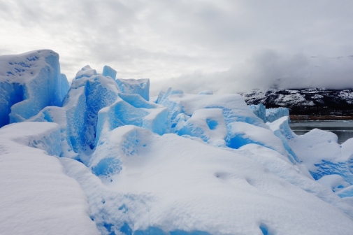
Beautiful blue ice

Our group’s first glimpse of the glacier drew audible gasps.  The glacier is magnificent.  A huge expanse of blue-hued ice that stretched back into the foggy horizon.  It was unlike any other natural wonder I had ever seen.  We spent an hour or so at the boardwalk area, which allows you to see the northern side of the glacier up close.

Northern side of Perito Moreno Glacier

Well-constructed and strategically placed walkways around the northern side of the glacier

Northern side of Perito Moreno Glacier

On one of the various walkways near the glacier

Even after an hour of taking in the spectacular sight of the glacier from all angles, the feeling of awe does not disappear.  I recalled to Jason about my first time seeing the Grand Canyon in the United States.  It was amazing when we first approached the canyon; but after 10 minutes, the view got a bit old and I was ready to leave.  With this glacier, however, I found that every time I looked away for a few seconds and caught sight of the glacier again, it would take my breath away.

We also got to board a boat that takes you right up to the southern side of the glacier.  One of the coolest things you can see while visiting the glacier is catching a rare moment when ice calves or breaks off from the main glacier.  It makes a incredible thunderous crack before giant slabs of ice fall away into the water.  We saw a couple of smaller ice chunks break away from the northern side but was never able to capture it on camera.

Southern side of Perito Moreno Glacier

Chunks of ice that had broken off the main glacier

Later on that day, as the group started packing up and putting their cameras away, the loudest crack I’ve heard all day split the air.  It happened so quickly that I didn’t get a chance to take my camera back out.  You’ll have to take my word that it’s pretty incredible to see in person.  I was able to get my camera out to capture a bit of the aftermath of the calving glacier though.

Southern side of Perito Moreno Glacier (glacier calving aftermath)

The aftermath of ice calving off the glacier

I would’ve been happy just admiring the glacier from the boat, but Jason and I were lucky enough to walk on the glacier!

Perito Moreno Glacier, Argentina

Another group of glacier trekkers that were making their way off the ice.

They strapped everyone up into crampons and gave us a few quick tips (“don’t walk with your feet too close together or you might end up stabbing yourself in the foot”)

Crampons for the glacier trekking

One of the guides helping me get fitted for crampons – HUGE metal spikes that they tie to your shoes. One lady wore high-heeled boots. Not sure how they found crampons for her.

And then we were off!

Walking on Perito Moreno Glacier

The first few hesitant steps on the glacier with crampons

Walking on Perito Moreno Glacier

In a couple of minutes, we were walking like pros. Crampons are like winter tires for people.

The steep parts were a little tricky but once you got the hang of it, it was pretty exhilarating walking on top of a glacier.

Glacier walking on Perito Moreno Glacier

Glacier walking!!

Glacier walking on Perito Moreno Glacier

Some awesome backdrop while walking on the glacier

Glacier walking on Perito Moreno Glacier

It’s not all fun and games. I got lectured for walking too close to this giant sinkhole.

Our guides even surprised us with a little treat near the end: Scotch on the rocks over glacier ice and alfajores!  Talk about an extravagant refreshment break.

Refreshments during our glacier walk

Now that’s what I call a refreshment break – Scotch on the rocks and sweets!

Towards the end of the day, the skies even cleared up a bit.  The glacier against the mountain setting is pretty breathtaking.  Seriously still can’t believe how beautiful Patagonia is.

Perito Moreno Glacier, Argentina

Mind-boggling that we got to walk on this!

Perito Moreno Glacier, Argentina

View of the glacier while on the glacier

Bye glacier,  hopefully we’ll be back one day.  Don’t you go anywhere.

Perito Moreno Glacier, Argentina

View of Perito Moreno Glacier as we motored away

Trekking into the Colca Canyon

After a restful week in Arequipa, we were ready for another beat-down trekking adventure. Arequipa is a main launching point for the surrounding canyon country and Jason had been itching to trek the Colca Canyon, which is about 200km north of Arequipa.

Colca Canyon, Peru

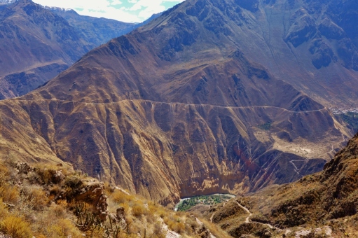
View of the Colca Canyon from the start of the hike

The Colca Canyon is one of Peru’s spectacular natural sights, although it’s often overshadowed by the country’s other attractions (i.e. Machu Picchu). It’s twice as deep as the famous Grand Canyon in the United States and is actually the world’s second deepest canyon – just few kilometers shallower than the nearby Cotahausi Canyon.

We decided to set up our base in nearby Chivay, a popular market town that still retains a lot of its traditional country origins.

Chivay, Peru

Town of Chivay, Peru

Chivay, Peru

The market bustling in the mornings in Chivay, Peru

It’s a logical entry point into the canyon country, and holds it own with many hiking trails and some of the most impressive and expansive Incan farm terracing on the continent.

Incan terraces from Coporque to Yanque, Peru

Incan terraces along our bike ride

We spent our first day in Chivay on rented bikes, touring the surrounding smaller towns further up the valley.

Scenery around Chivay, Peru

Beautiful day for a bike ride (Chivay, Peru)

We started off making our way to the nearby town of Coporaque. There are a couple of ruins in the small town but we didn’t stop long. Out of Coporaque is a (mainly) downhill ride to the orange bridge which crosses the Rio Colca and brings you into Yanque.

Rio Colca, Peru

Unfortunately, the downhill out of Coporaque meant a crazy uphill from Yanque back to Chivay. My thighs are burning just thinking about it.

Donkey Crossing in Chivay, Peru

Warning: Donkey Crossing

Just a warning to non-bikers: it is NOT a quick ride. We were told it’s a quick 2-3 hours bike tour. We took about 5-6 hours because we were not anticipating the intense uphill riding (i.e. walking our bikes uphill) we encountered at the end of our circuit.

Biking around canyon country, Peru

Biking and photography at the same time!

Successfully warmed up, we embarked on our 2D/1N trek into the Colca Canyon the next day. Although almost all tour companies in Chivay offer Colca Canyon treks, it’s pretty easy to do the trek solo.

Colca Canyon, Peru

Trekking into Colca Canyon

To properly experience Colca Canyon trekking, you have to make it as far as the little town of Cabanaconde. (Only about 20% of Colca Canyon visitors get this far – most only make it to the scenic viewpoint of Cruz del Condor). The shortest way to the canyon floor is the 2-3 hour hike from Cabanaconde to Sangalle (aka ‘the oasis’).

Colca Canyon, Peru

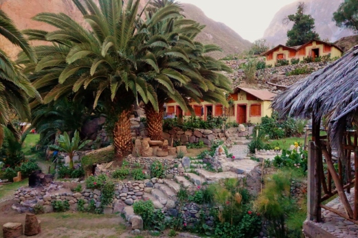
It’s a 1200m descent on steep, zigzagging paths, where upon reaching the bottom of the canyon, you can stay overnight in basic thatched-roof bungalows (S/.15 or CDN $7/pp) or campgrounds.

Colca Canyon, Peru

The ‘oasis’ is almost immediately visible once you start the trek into the Colca, but like any desert oasis, it’s deceptively far. (and here’s hoping it’s not just a beautiful mirage)

Sangalle, Peru (Colca Canyon)

View of Sangalle (the oasis) from afar

Sangalle, Peru (Colca Canyon)

Getting closer to the oasis!

After 2.5 hours of watching the oasis grow closer and closer, we finally made it.

Sangalle, Peru (Colca Canyon)

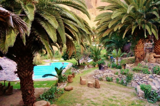
What the oasis looks like, up close and personal

Sangalle (“the oasis) is beautiful. A rich patch of green bound in by the Rio Colca and the sheer canyon walls.

Rio Colca, Sangalle, Peru

Rio Colca cutting through the Colca Canyon

Bungalows (Sangalle, Peru)

The little bungalows we stayed in while in Sangalle.

With no electricity, no phones, and no internet access, there was no choice but for us to relax. I even finally perfected the art of lounging in a hammock!

Sangalle, Peru (Colca Canyon)

Thanks to Jason’s tutelage:

Sangalle, Peru (Colca Canyon)

After a evening of candlelight dining (out of necessity, not romance), card-playing, and star-gazing, we called it a night.

The next day, we left around 8am to start the tough climb out of the canyon. We were told it’ll take 3-4 hours, so we wanted to start in the cooler morning air. I’m a slower trekker than Jason, so I decided to get a head start on the trail, while Jason was packing up.

Sangalle, Peru (Colca Canyon)

Goodbye beautiful oasis!

As I was climbing up, I noticed that the trail seemed much narrower and steeper than the climb down. ‘How did I climb down this yesterday, with such ease?‘, I found myself wondering. Typically, the climb down requires more concentration than the climb up, since the trail is covered with loose rocks. Any momentary lapse in concentration would likely result in me losing my footing and slipping (not enough to make me fall flat on my arse, but enough to make me concentrate hard for the next 30 minutes).

Colca Canyon, Peru

Concentrating on the trek down

However, on the climb up, I was concentrating way too hard for it to seem right. After about 20 minutes up, I realized that I had taken the wrong trail (Groan!) And by ‘wrong trail’ I meant the crazy-steep, really narrow trail that perhaps only mountain goats were sure-footed enough to take. So I had to turn around, edge slowly back down, and start all over again. By then, Jason had already caught up with me! So much for my head start 😛

On top of that, (oh, you’re gonna laugh) after we trekked up for about half an hour, I suddenly realized that I had left my iPhone in our bungalow. Back in the oasis. Back at the bottom of the canyon!

So Jason decided that I should keep on going, while he turned back around to trek back down into the oasis to get it. He gave all his valuables to me, tied his backpack to a nearby post, and sprinted back down. I continued my slow ascent up the canyon. Every 10 minutes or so, I would turn around and see if I could catch a glimpse of him.

Two and a half hours later, I was finishing the last leg of the trek out of the canyon and I still hadn’t caught sight of him. I was really getting worried – until some power trekkers caught up with me near the top and told me that they had seen my husband (i.e. the only other Asian person in the canyon) further down. About 20 minutes after I reached the top, he rounded the corner into view.

And he had my iPhone with him. That’s my hero! 🙂

Colca Canyon, Peru

My hero!

Machu Picchu: It’s All About the Journey…

…and I guess, a little about the destination too.

Having started our 6 months of travel with hardly more planned than a one-way ticket out of Canada, we found ourselves in Peru without anything booked for our visit to Machu Picchu.

There are several ways to see South America’s most popular tourist attraction, but we knew we wanted to trek our way to the famous ruins. (Interesting little tidbit from our guide: most people take the train to see Machu Picchu, only about 20% trek). 

PeruRail - train to Machu Picchu

The train that takes you to and from Machu Picchu (PeruRail). We opted against taking it to Machu Picchu. But there was no way we’d pass up the return trip after 4 days of trekking!

The most popular trek is the classic Inca Trail but since the Peruvian government has restricted the number of Inca Trail trekkers, only 500 people can take that trail up a day (including guides, porters, donkeys…ok, not donkeys).  As a result, it has become nearly impossible to book the Inca Trail unless you’ve done a bit of planning beforehand.  During the high season (which we’re in right now), the trail is booked up months in advance.  And since we had no idea when we’d be in Peru when we first started out travels, we were out of luck when it came to the Inca Trail.

Luckily for us, there are several great alternative trekking routes to Machu Picchu that don’t require booking way in advance.  Jason did some research and after comparing the available routes, we decided that the Salkantay Trek was right up our alley.

Salkantay Trek, Peru

The Salkantay Trek

It’s a demanding, longer, and more scenic trek to Machu Picchu than the Inca Trail.  Available in a 4D/3N or 5D/4N option, we naively chose the 4D/3N option thinking it may be a little easier.  Wrong!  The shorter trek is more difficult, we discovered –  as we had to cover the same ground but in a shorter amount of time.

Peak of Salkantay Moutain, Peru

Our first glimpse of Salkantay Mountain from afar. We’ll be coming to within 1500m of its peak.

As for which trekking company to go with, we researched quite a few companies and read tons of reviews, as we wanted to make sure we chose an ethical and eco-friendly trekking company.  There are a lot of trekking companies out there, but not all treat and pay their porters well and some do not care about keeping the environment clean and carrying all the waste back out of the trekking route.  It came down to two companies that seemed to offer all the things we were looking for – the well-established Llama Path and the newer but well-reviewed Inca Trekkers.  After reading up on the differences between the two companies, we decided to go with Inca Trekkers as we felt a newer company would likely ‘go the extra mile’ in terms of offering their clients an excellent experience, as opposed to a well-established company that already had the benefit of building a good reputation (i.e. comments on TripAdvisor confirmed the growing complacency of Llama Path).  Looking back, we really appreciated the things that Inca Trekkers did do to go that extra mile (i.e. holding the briefing session in the comforts of your hostel, bringing you back to your hostel after the trek instead of ending the tour in Aguas Calientes – the town at the foothills of Machu Picchu).

One more bonus: on a tour that typically consists of 12-16 people, it would just be Jason and I! Score!

Oh, and If you want a more detailed itinerary of the 4D/3N Salkantay Trek, click here.

Day 1: It’s all Uphill from Here

On the brilliantly sunny first day, we started off hiking to the highest point of the trek – a breathtaking high pass of 4700m (called Salkantay Pass) right next to the spectacular, snow-covered peaks of Salkantay mountain (6270m).

Soraypampa - start of Salkantay Trek

At the beginning of our trek in Soraypampa with our guide, Hugo. You can see the giant peak of Salkantay looming in the background.

This scenery was magnificent – glacier peaks on our right, green mountain tops on our left.  We even spotted a couple of Condors – Peru’s national bird.  (It’s supposedly good luck when you spot one – so we hoped this was a good sign for the upcoming couple of days).

Approaching Salkantay Mountain, Peru

Approaching Salkantay Mountain. You can appreciate the sheer size of the mountain by comparing it to the people on horses at the bottom of the picture.

The 3-hour uphill battle was the hardest part of the 4-day trek.  The incredibly thin air at that altitude (the highest we’d been, at that point) meant that you feel like you’re sprinting up the mountain.  Your heart is racing, you’re gasping for oxygen that doesn’t exist, and your legs can barely plod forward.  We had to constantly stop every couple of minutes to catch our breath.  High altitude climbing is really difficult, even with all the extra precautions we took: taking pills to prevent altitude sickness (soroche, as its known in Latin America), eating chocolate to increase our blood glucose levels, sipping water to stay hydrated. 

Salkantay Trek to Machu Picchu, Peru

Jason posing for a Salkantay Trek ad 😛

People were not kidding when they tell you to make sure you acclimatize in Cusco (3300m) for a few days before doing this trek.  Otherwise, you might have to turn around and head back down before the trek even starts.

Salkantay Trek to Machu Picchu, Peru

Finally reached our lunch spot! We’re at a breathless 4200m here.

We stopped for lunch at a plateau near the top and had some deliciously hot chicken soup, avocado salad, fried trout and rice, and hot cups of tea.  Quite possibly the best lunch ever after trekking in the freezing cold temperatures for 3 hours.  Our chef was amazing and we had him all to ourselves!

Lunch time during Day 1 of Salkantay Trek to Machu Picchu, Peru

Jason, happy as a clam, as we warmed up with hot tea during lunch.

After refueling, we put on a few additional layers of clothing to continue to climb for another hour to reach the top of Salkantay Pass (4700m) – the highest point of our trek.

Salkantay Pass, Peru

Jason and I huffing and puffing at the highest point of our trek – the top of Salkantay Pass. We made it! (barely!)

Then it was downhill for another 2 hours until we reached our camp for the night.  Our tent was already set up and there was hot chocolate, tea, and the best salted popcorn we’ve ever had waiting for us!

Warm water to wash up on Salkantary Trek to Machu Picchu, Peru

They provided warm water to wash up! Talk about luxury camping.

Day 1 campsite on Salkantary Trek to Machu Picchu, Peru

Our home for the next few days. Pretty roomy actually – it had a front “foyer” for us to store our muddy hiking shoes.

Our campsite was at 4200m – the air still really thin and freezing cold!  Once we got into our high-tech sleeping bags, we didn’t want to come back out. I debated for half an hour in my warm sleeping bag before deciding that I really should make one last run to the washroom before heading to sleep.  It was 8:30pm.  When you’re camping with no electricity or even a campfire, it’s pretty  much bedtime when it gets dark.

Day 2: Downhill into the Jungle

Salkantay Peak, Peru

The mountain we slept under and the view we woke up to.

Instead of the usual 6:00am start time, we started at 7:00am since our guide, Hugo, decided that we were actually pretty good trekkers (based on our progress and speed from the first day).  Yay! The extra hour of sleep was very much appreciated since getting out of the warm cocoon of a sleeping back and stepping out into the freezer-like temperatures outside our tent was really REALLY difficult to do.

Day 2 of Salkantay Trek to Machu Picchu, Peru

Wearing every single piece of clothing we brought on the morning of Day 2

We started the day wearing every single piece of clothing we brought with us and spent the next 9 hours hiking downhill from the glacier-covered mountains into the jungle.

Day 2 of Salkantay Trek to Machu Picchu, Peru

Cooling off at the waterfall

Luckily there was cloud cover, or the jungle would’ve felt even more tropical.  We stopped every hour to shed another layer of clothing as we descended deeper and deeper into the valleys of the subtropics.

Descending into the subtropics of Salkantay Trek

About an hour into Day 2 of our trek, we were already into the beginning of the subtropics of Peru.

We reached our lunch spot on a local farm just before the clouds broke and the rain poured!  We had delicious corn chowder and a platter of protein to help heal our aching muscles.

Day 2 of Salkantay Trek, Peru

Another delicious lunch!

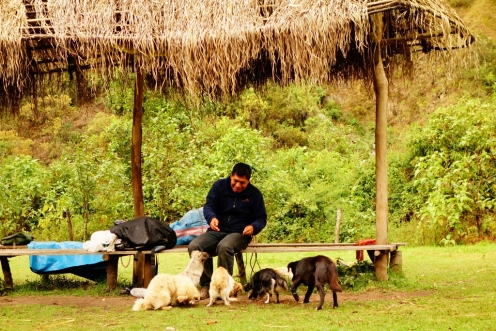
Jason made friends with some of the farm’s cute little dogs.  They had such wonderful little personalities.

Day 2 of Salkantay Trek, Peru

Adorable dogs at the farm where we had lunch

Awww, we totally miss our dog, Weezer.  Gratuitous shot of Weezer 🙂

Puggle

Our little guy that we left back at home in Toronto

We set off again just as the sun shot out through the clouds.  Perfect timing.
Day 2 of Salkantay Trek, Peru

Our guide, Hugo, feeding the dogs on the farm at lunch

The grueling 9-hour trekking day came to an end at a small town near the base of the mountain on which the Llactapata ruins lie.

Day 2 of Salkantay Trek to Machu Picchu, Peru

Random cows relaxing in the middle of the road.

We were hot and sweaty from the long hike through the subtropics, so Jason decided to take a dip in the frigid waters of Rio Urubamba.

Day 2 of Salkantay Trek to Machu Picchu, Peru

Setting up camp the night of Day 2

He also brought along a bar soap since we hadn’t showered in a couple of days 😛  He said it was actually really refreshing.  By refreshing, he meant his skin felt like it was on fire after dipping into the icy cold waters.

Rio Urumbamba, Peru

Jason debating whether to jump into the icy waters of Rio Urubamba

Before dinner, we talked with our guide, Hugo, as to whether we want to do the 7-hour climb over Llactapata the next day (4 hours up, 3 hours down in poor weather conditions).  It would be a very difficult climb and descent as it was very steep and can be dangerous when it’s rainy.  Jason really wanted to do it since the site of these ruins was part of Hiram Bingham’s original route, but my toes had taken a beating from the entire day of trekking downhill and were in a lot of pain.  Before we arrived in Peru, both Jason and I had read an excellent (and funny) book by Mark Adam called Turn Right at Machu Picchu (2010).  We had wanted to read up more about the history of Machu Picchu and the famous explorer Hiram Bingham who “rediscovered” the ruins in the early 1900s and the book provides an excellent layman’s account of Inca history and a first-person view of the Inca Trail and the alternative routes.

Plaque of Hiram Bingam at Machu Picchu

Plaque of Hiram Bingham (Taken at the entrance of Machu Picchu)

Having read all about Llactapata and its ruins, we both wanted to climb and see the ruins.  It’s been called the “suburb of Machu Picchu” since it’s so close to the forgotten Incan city – you can actually get a clear side view of the entire site of Machu Picchu from Llactapata.

Since Hugo was leaving the decision up to us, I was leaning towards skipping the climb to Llactapata and meeting Jason and Hugo on the other side at the Hydroelectric station.  However, over dinner, Hugo made the executive decision that all three of us would be doing the climb the next day.  He told me that I was a good trekker and was in good shape for the climb since it wasn’t my knees that were bothering me.  If I had any trouble descending from Llactapata then Jason and himself could always help me down.  His confidence in me, along with the finality of his decision, renewed my own confidence in myself.  I was actually excited for the climb now!

Day 2 of Salkantay Trek to Machu Picchu, Peru

Self-portrait on Day 2 of the trek

After another incredible meal by our chef, Mario, we watched the stars for a bit before settling into our sleeping bags.  It was so much nicer not being in sub-zero temperature. 🙂   We slept early knowing that we had a tough day ahead of us.

Day 3: A Steep Climb up to Llactapata

Salkantay Trek, Peru

Gorgeous mountain scenery on the Salkantay Trek

We started at 6:30am the next morning after a hearty breakfast of sausage, omelettes, and bread.  We got off to a good brisk start and made it up to the top of Llactapata in just under 3 hours.  It was a hot, sunny day so I’m glad we started in the cool, early morning air.  The view of Machu Picchu at the top was pretty awesome – our first glimpse of the famous city!

Machu Picchu from Llactapata

The view of Machu Picchu from Llactapata.  You’ll need to squint a bit, it’s a little hard to see.

The Llactapata ruins themselves were pretty cool – it showed us what Machu Picchu would’ve looked like prior to its rediscovery and restoration.

Llactapata Ruins

The Llactapata ruins – overrun with flora

We sat in the shades of the ruins while Hugo gave us a little Incan history lesson.
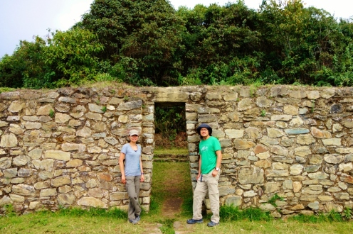
Llactapata Ruins

Llactapata Ruins

We then made it back to the bottom in 2 hours (we had the ideal trail conditions – sunny and dry) and then continued for another hour along the river to the Hydroelectric station for lunch.

Day 3 of Salkantay Trek

Trekking towards the Hydroelectric station on Day 3.

After lunch was the last leg of our trek.  After all the uphill through sub-zero temperatures and downhill through the subtropics, you would think the final leg of our trek would be easy – a flat hike in a mild climate along the train tracks from the Hydroelectric station to Aguas Calientes (the small town at the base of Machu Picchu that everyone has to pass through to get to the famous Incan site).  Turns out that the final 3 hours was much harder than anticipated.  By then, our bodies started really complaining from all the abuse.  Our muscles started stiffening up and screaming in pain and we pretty much hobbled our way through the final excruciating hours.

Railroad tracks leading from the Hydroelectric station to Aguas Calientes - Salkantay Trek

Hobbling along the railroad tracks to Aguas Calientes

We finally made it into town around 4pm where we flopped down on a patio and had the coldest, best-tasting beer we’ve ever had in our lives.  We checked into our hostal, had our first shower in 3 days, and met Hugo for dinner.  We cleaned up pretty well…Hugo hardly even recognized us.

Dinner at Aguas Calientes

Dinner at Aguas Calientes

Day 4: Machu Picchu

Some people who like to remain purists prefer to hike up from Aguas Calientes to Machu Picchu.  After 3 grueling days of the Salkantay trek, I was so relieved that Hugo had planned for us to take the 20-minute bus ride up from the town to the steps of Machu Picchu.  We lined up on a rainy morning outside the bus stop to catch the 7am bus up.

Terraces of Machu Picchu

Terraces of Machu Picchu

The sky was overcast and drizzly as we entered Machu Picchu.  Hugo decided not to take us out to the look-out spot yet as the entire site was still under cloud cover.  We walked around the site, while Hugo provided us with wonderful little tidbits of information and history.

Perfect Incan stonework at Machu Picchu

Perfect Incan stonework at Machu Picchu – you can’t even fit a knife between the stone blocks.

He’s actually writing a book about certain parts of the ruin  – specifically an acoustic room that allows sound captured in any of the window alcoves to be clearly transmitted to any other window alcove in the room – kind of like transmitting sounds through tin cans and string but…without any tin cans or string 😛

Acoustic Room in Machu Picchu

Jason appreciating the sounds of the Acoustic Room in Machu Picchu

After the tour, Jason and I had time to wander around the site by ourselves.  We waited patiently for the cloud cover to lift so that we can take a few photos of the entire site.

Foggy Machu Picchu

Waiting for the cloud cover to lift at Machu Picchu

We trekked the 20-minutes to the nearby Incan drawbridge. Pretty scary trek as there are parts that that are only 2 feet wide and then a sheer drop into oblivion.  Jason, who is quite afraid of heights, caressed the rock wall the entire route there.

Incan drawbridge, Machu Picchu

Jason timidly peeking beyond the drop, on the way to the Incan drawbridge

You can only take a picture of the bridge from afar now, since in 2005 a visitor crossed the bridge and sadly fell to his death.

Incan drawbridge, Machu Picchu

The Incan drawbridge can be seen in the lower right part of the photo

We wandered back to the Machu Picchu ruins to discover the clouds slowly lifting!  Hugo had told us that sometimes, the clouds  never lift and disappointed guests have to go home without ever glimpsing the ruins in full.

Machu Picchu

Fog lifting over Machu Picchu (finally!)

Machu Picchu

Another selfie in front of Machu Picchu

The views are really quite spectacular up there.  The clouds that linger around the mountain tops lend such a mysterious aura around the entire lost city.  It’s interesting to think that experts are still trying to accurately figure out why this place was built in the first place.

Cloud-covered mountains near Machu Picchu

Mysterious cloud-covered mountains near Machu Picchu

Even with the crowds of tourists swarming around the site, Machu Picchu still manages to remain mysterious and full of secrets.